{{item.videoDuration}}
{{item.title}}
{{item.text}}

{{item.videoDuration}}
{{item.title}}
{{item.text}}
Drone powered solutions are best suited to sectors that require both high quality of data and mobility. Specifically, businesses that manage assets dispersed over large areas have a long history of issues that new drone solutions can fix. Broad capital projects, infrastructure maintenance, and agriculture will benefit greatly from integrating drones into day-to-day business. Insurance and mining will have to consider potential process improvements as they gain new levels of data quality and accessibility. And the entire transport industry will surely change its concept of last-mile delivery.
Delivery of digital portfolios of assets for transaction or audit purposes in the COVID-19 travel restrictions environment.
Find out more
Strategic consulting for a variety of clients: start-ups, established players entering the drone sector, governmental entities and ANSPs (Air Navigation Service Providers).
Advisory on the drone technology selection and integration into operational processes for a specific industry.

Image data processing and analytics delivering technical products and analytical reports.
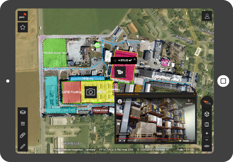
An application that integrates, manages and delivers the drone collected data in one convenient, easy to use interface of a web browser. It is a tool for measuring and analysing geospatial data and also for integration with data from your company. The application is adjustable and modular, while the available image data in it is easily comparable as a result of its quantification.